Trip Report – Colorado Fall Color 2016 Part 3

Continuing on from Part 2, the next stop was Maroon Bells for sunrise. Located in the Snowmass Wilderness, this is a very popular sunrise photo location. Unfortunately a storm was blowing through so I didn’t get the alpine glow sunrise that you typically see here. Instead I got a nice pre-dawn shot (above) with some stars visible between the clouds and a late morning shot when the sun came out and the wind stopped just long enough to get a decent reflection in the lake.
From there I traveled south over Independence Pass, stopping at a couple of spots to take photos of the spectacular landscape before heading to Great Sand Dunes National Park.

The Ghost Town of Independence:

Roaring Fork River:

Snow Squall:

Twin Lakes:

I arrived at Great Sand Dunes in a windstorm, so I didn’t spend much time on the dune field.  Clouds over the park with clear skies to the west provided some nice storm light on the Dunes.

Dune field from the Entrance Road:

Dunes from the Entrance Road

High Dune Hikers:

Dunefield Storm Light:

Look for Part 4 covering the two railroad photo charters this trip was centered around in a couple of weeks.

Through The Lens 86 – Maroon Bells

Maroon Bells is a popular location to photograph sunrise in Colorado, especially in the fall when the aspen trees on both sides of the lake turn gold.  A storm was blowing through the morning I was there, so we didn’t have the typical alpine sunrise reflected in the lake. There was a short break in the clouds after sunrise that allowed the photographers assembled at the lake to get a couple of photos before the clouds closed in again.

I’ll post Part 3 of my Colorado Fall Trip Report on Tuesday, covering Maroon Bells, Independence Pass and Great Sand Dunes National Park.

Trip Report – Colorado Fall Color 2016 Part 2

Devil's Lookout

Continuing where we left off in Part 1 of the trip report, after leaving Mesa Verde National Park, I drove North to Montrose Colorado to be in position for sunrise at Black Canyon of the Gunnison National Park.

Black Canyon of the Gunnison became a National Park on October 21, 1999, encompasing 30,750 acres and is known for its incredibly steep cliffs and narrow canyon.  At its narrowest point, Chasm View, the canyon is 1,100ft wide at the rim, 40ft wide at the river and 1,820ft deep!  This unique steepness and narrowness is caused by the steep route the Gunnison River takes through the canyon.  It averages 34ft of drop per mile which causes the river to cut deeper into the canyon faster than the walls can erode and widen the canyon.

Island Peaks:
Island Peaks

Pulpit Rock:
Pulpit Rock

Chasm View:

Chasm View

The canyon is difficult to photograph during the day due to the huge contrast between the shadows and the sunny side of the canyon. I think this park may be best captured in the pre-dawn and post sunset light.  A second trip to better capture this park is definitely in order.

Part 3 of the trip report will cover Maroon Bells and Great Sand Dunes National Park.

Trip Report – Colorado Fall Color 2016 Part 1

Last fall I had the opportunity to attend two photo charters in Colorado, so I extended the trip to allow time to visit a couple of national parks.  First up was Mesa Verde National Park. Created on June, 29th, 1906 by Theodore Roosevelt, Mesa Verde National Park was the first of it’s kind. All prior National Parks were created to preserve nature. Mesa Verde was established to preserve the works of man.

I only had one afternoon to visit Mesa Verde this time, but that was more than enough time to capture the two images I had in mind. First was sunset at Square Tower House:

Square Tower House Sunset

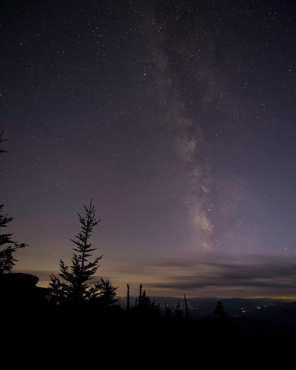
Second was the Milky Way over Park Point:

As a bonus I got a post sunset shot of the old Knife Edge Road that served as the entrance to the park for many years.  The went around the rock formation to the left in the image below, literally only one car width wide.  Thankfully they’ve built a wider road to replace it:
After finishing with the milky way shots, I headed north to the Black Canyon of the Gunnison National Park.  More on that in Part 2.

Through The Lens 45 – Mail Pouch Memories

Mail Pouch Memories

Sometimes you’re in the right place at the right time. Last fall, I was on my way from Cass, WV to Great Smoky Mountains National Park and happened to drive by this Mail Pouch Barn on a beautiful foggy morning. The owner graciously allowed me to photograph the barn. These roadside treasures of America’s past are disappearing quickly. When you see one, make sure to stop and photograph it because it may not be there the next time.

Through The Lens 43 – Cass Fall Photography Workshop

Its that time of year again. Tomorrow I’ll be attending the Cass Photography Workshop for the third year in a row. Even though I’m arriving a little late due to a prior commitment, I’m looking forward to seeing what Walter and Clayton have in store for us this year.

Trip Report – Great Smoky Mountains National Park 2015 – Part 3 – Cades Cove

For the final part of my Great Smoky Mountains 2015 Trip Report, we’ll visit my favorite place in the park – Cades Cove.

Cades Cove is home to several homesites, churches, and lots of wildlife, making it a great place for photography. Here’s a few of my favorites from last fall:
Cable Mill

Cable Mill

Cades Cove Methodist Church

Cades Cove Methodist Church

Hyatt Lane Sunrise

Hyatt Lane Sunrise

Becky Cable Home

Becky Cable Home

Primitive Baptist Church Road

Cades Cove - Primitive Baptist Church Road

Tipton Barn

Tipton Barn

Sparks Lane Sunrise

Sparks Lane Sunrise

Thanks for following along.  If you missed the the first two parts you can find them here:  Part 1  Part 2

Trip Report – Great Smoky Mountains National Park 2015 – Part 2 – Sunsets & Night Photography

Sunset - Clingman's Dome

The clear skies that made waterfall photography difficult did create opportunities for great sunset and night photography on Clingman’s Dome and along the Newfound Gap road.

Sunsets on Clingman’s Dome are fun to watch.  On a clear day just before sunset a line of photographers appear along the edge of the parking lot to get the classic shot of the sun dropping behind the distant mountains. Stick around after the sun disappears and the colors turn from oranges and purples to pastel pinks and blues.

Twilight - Clingman's Dome

For a little different perspective, a climb to the top of the observation platform gets you above the tree tops.  If you decide to make the climb, allow plenty of time.  The path is steep and at high elevation.

Sunset Clingman's Dome

Once it’s dark enough for the Milky Way to appear, the trees at Clingman’s Dome and the overlooks on Newfound Gap Road make interesting foregrounds.

Clingman’s Dome Trail:

Milky Way - Clingman's Dome

Milky Way - Clingman's Dome

Morton Overlook:

Milky Way - Morton Overlook

That’s it for Part 2.  If you missed it, please have a look at Part 1 of the trip report.  Check back in two weeks for Part 3 – Cades Cove.

Trip Report – Great Smoky Mountains National Park 2015 – Part 1 – Waterfalls & Cascades

Spruce Flats Falls

Following the Cass Fall Photography Workshop, I made the trip down to Pigeon Forge to see the Great Smoky Mountains National Park for the first time.  My two priorities for the trip were spending time in Cades Cove and shooting as many waterfalls as possible.  While I was successful on the first goal, sunny weather all week made waterfall photography a challenge.  But the sunny weather brought great sunsets and clear night skies on Clingman’s Dome so like all photography adventures, it was just a matter of chasing the light.

To keep the length reasonable, I’m going to split the trip report into three sections:  Waterfalls & Cascades, Sunsets & Night Photography and Cades Cove.

First up is Waterfalls.  As I mentioned earlier, many of the waterfalls are difficult to shoot on bright sunny days.  Dappled light and harsh shadows make for a difficult exposure, so instead of hiking the waterfalls back to back as I planned, getting decent waterfall shots became a game of shooting in the shadows.  After some quick research on the topography surrounding the waterfalls, I was able to guess when the surrounding hills would leave them in shadow, making for an easier exposure.

Big Creek Cascades - Autumn

Big Creek Cascades

Midnight Hole

Midnight Hole

Midnight Hole Cascades

Midnight Hole Cascades

Mouse Creek Falls

Mouse Creek Falls

Baskins Creek Falls

Baskins Creek Falls

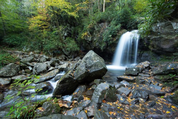
Grotto Falls

Grotto Falls

Laurel Falls

Laurel Falls

Lynn Camp Cascades

Lynn Camp Cascades

Spruce Flats Falls

Spruce Flats Falls

All things considered, I’m happy with the waterfall shots I was able to get and since I didn’t get them all, I guess I’ll have to go back!

Check back in two weeks for Part 2 – Sunset & Night Photography.